Tropical Storm Chantal has made landfall on the East Coast, impacting the Carolinas on Sunday morning.
Why It Matters
Chantal is the third tropical storm of the 2025 Atlantic hurricane season so far, following Andrea and Barry, both of which took place in June. The storm has prompted flash flood warnings as it brings heavy rain and winds to coastal areas.
What To Know
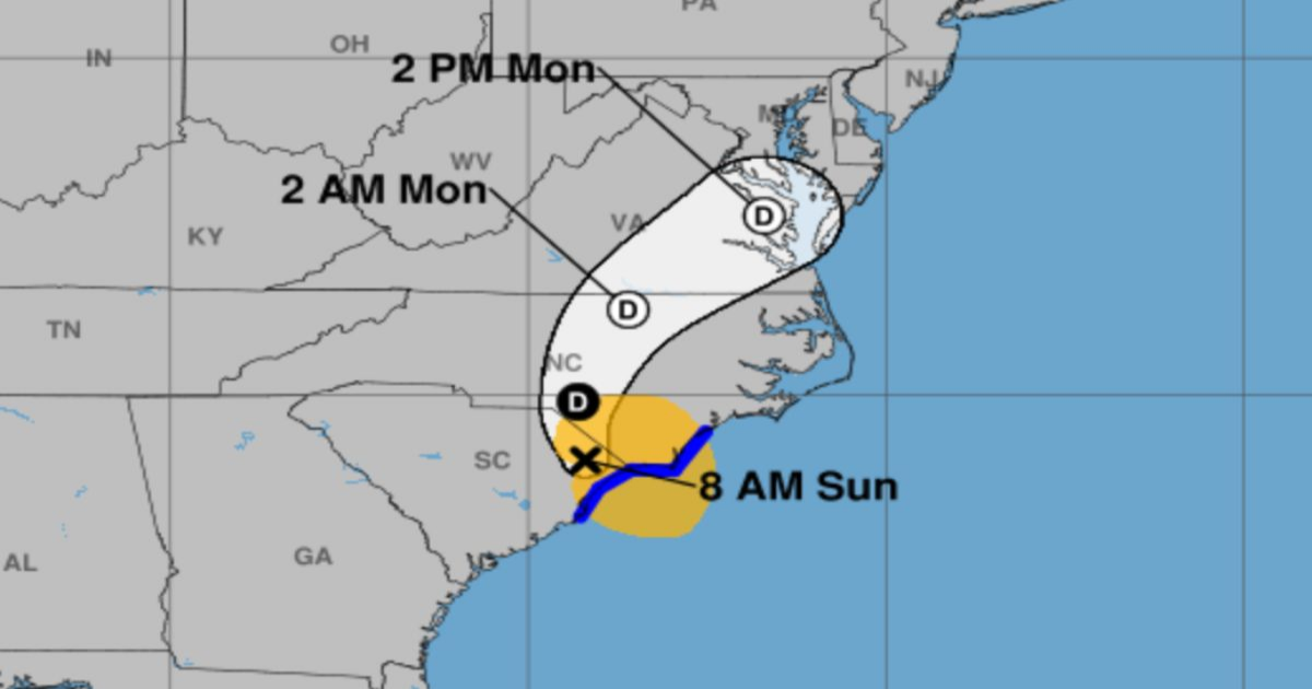
According to AccuWeather projection maps, the storm hit early on Sunday morning and is continuing inland and northward across the Carolinas, up through Virginia and Delaware. The National Hurricane Center (NHC) projects a similar path, with the storm expected to arrive in the Delmarva Peninsula around 2 p.m. ET on Monday.
Impacts are being felt across the region, with rain falling across eastern Florida and up to Delaware. AccuWeather forecasters have said that most areas can expect 1 to 2 inches of rainfall, while central and eastern North Carolina and northern coastal South Carolina will see heavier totals of 2 to 4 inches.

NHC map showing the projected path of Storm Chantal. NHC map showing the projected path of Storm Chantal. NATIONAL HURRICANE CENTER
The heaviest rainfall—between 4 and 8 inches—is forecast for a small area between Wilmington, North Carolina, and Myrtle Beach, South Carolina. The National Weather Service (NWS) has also issued tropical storm warnings and flood advisories in these areas.
“Flash flooding remains a threat as rainbands from Chantal move inland across northeastern South Carolina and eastern North Carolina,” the latest update from the NHC reads. “Chantal is expected to bring life-threatening surf and rip currents along the coast from northeastern Florida to the Mid-Atlantic states during the next day or so. Beach goers should heed the advice of lifeguards and local officials.”
The South Carolina Emergency Management Division (SCEMD) has urged all coastal residents and visitors in the storm’s path to:
- Stay out of the ocean during periods of high rip current risk.
- Monitor official weather alerts and trusted local news sources.
- Follow all instructions from local emergency officials.
What People Are Saying
AccuWeather senior meteorologist Tyler Roys: “The heavy rainfall can lead to flooding, especially in low-lying and poor drainage areas.”
The National Hurricane Center in its 5 a.m. EDT update: “Heavy rainfall across portions of northeastern South Carolina will cause some flash flooding concerns from Tropical Storm Chantal today and across portions of North Carolina through Monday. Isolated to scattered flash flooding could occur within more urbanized areas.”
What Happens Next?
Chantal is not expected to develop any further as it began close to land and due to “moderate wind shear or disruptive breezes in the lower and middle parts of the atmosphere,” AccuWeather reported.