MINNEAPOLIS (FOX 9) – Severe storms are expected to push through Minnesota on Monday evening.
You can find live updates on the severe weather below.
Get location-based weather alerts on your mobile device by downloading the FOX 9 weather app and allowing notifications.
6:30 p.m. – Severe thunderstorm watch issued
A severe thunderstorm watch was issued for parts of Minnesota, including the Twin Cities metro. It is in effect until 1 a.m.
The National Weather Service says hail, wind and frequent lighting are the main threats.
Meanwhile, severe thunderstorm warnings have been issued for far western Minnesota as storms begin to enter the state from South Dakota.
Monday storms: What to expect
What to expect:
FOX 9 Chief Meterologist Ian Leonard says storms are rapidly developing across central South Dakota Monday afternoon, with the expectation that the storm size and intensity will increase as they track further east into the early evening.
A line of severe thunderstorms are expected to move into western Minnesota around 7 p.m. and track east, and will dissipate by 3 a.m. Tuesday.
The greatest threat with these storms is a damaging straight-line wind event called a Derecho that can stay in line and intact over hundreds of miles. It includes all variations of severe weather, from destructive winds to isolated tornadoes and heavy rain/flooding.
Monday’s forecast in Minnesota
Storm chances Monday:
Temperatures heat into the low 90s across southern Minnesota and the Twin Cities metro, though it will feel like the triple digits in some areas. Northern Minnesota will see cooler highs in the upper 70s and 80s.
After a sunny afternoon, storms are expected to develop later in the day and into the evening. The main threats are damaging winds, hail and isolated tornadoes – particularly in western Minnesota.
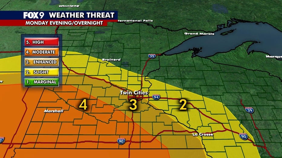
These storms carry a level 4 moderate risk of severe weather for southwestern Minnesota, a level 3 enhanced risk for the Twin Cities metro and a level 2 slight risk just north of the metro.
Extended forecast
What’s next:
Tuesday brings a break from the heat, though it will still feel humid. Highs will be in the 80s with partly cloudy skies.
By Wednesday, temperatures are cooler with highs in the upper 70s and dew points dropping into the 50s. This stretch of mild temperatures and lower humidity will likely last into the weekend.
Here’s a look at the seven-day forecast:

The Source: This story uses information from FOX 9 meteorologists.