Severe weather to persist overnight, move out around daybreak
Heavy storms with the threat of possible tornadoes will continue moving through Atlanta and the metro area overnight.
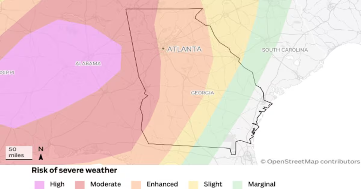
The National Weather Service issued a tornado watch until 4 a.m. Sunday for most counties from northeast to southwest Georgia. Metro Atlanta counties included in the watch are Fulton, Clayton, Rockdale, Henry, Paulding, Cherokee, Cobb, DeKalb, Gwinnett, Spalding, Coweta, Forsyth, Fayette, Hall and Douglas.
Some locals in North Georgia already had to hunker down before midnight after tornado warnings were issued in Cobb, Paulding, Cherokee, Gilmer and Fannin counties.
Heavy showers arrived in far northwest Georgia around 8 p.m. Saturday. The line of storms reached west metro Atlanta by around 11 p.m. It’s projected to continue through the city past 2 a.m. and then start moving out toward east metro Atlanta and East Georgia.
Severe weather should move out of the state by 8 a.m. Sunday, according to the National Weather Service.
More than 4 inches of rain so far in Carroll County
More than 4 inches of rain have fallen in parts of West Georgia, early Doppler radar estimates show.
Carrollton in Carroll County has seen 4.1 inches of rain; Cedartown in Paulding County 3.4 inches.
Atlanta has been relatively dry at .03 inches.
Troup County sheriff advises against driving until morning
The Troup County Sheriff’s office said it has received multiple reports of trees blocking roads.
“Highly recommended to not drive until the storms have passed in the morning,” it says in a travel advisory.
In a Facebook post, the sheriff’s office mentioned the West Point Road area near Hogansville.
Troup County is an hour southwest of Atlanta.
LaGrange is the county seat.
Heavy rain moved into LaGrange from a severe thunderstorm near Langdale, Ala., around 12:45 p.m.
High wind, rain and lightning were seen on traffic cameras in the city.
Flash flood warning in place for parts of metro Atlanta, west of city
Areas west of Atlanta, including parts of the metro, are under a flash flood warning until 6 a.m. Sunday, the National Weather Service reported.
Northwestern Cobb, northwestern Douglas, southern Bartow, central Carroll, southeastern Floyd, Haralson, Paulding and Polk counties are under that warning, which could impact small creeks and streams, urban areas, roads, underpasses and low-lying area.
Storm damage reports emerging across Georgia
Residents and officials across Georgia are starting to report storm-related damage.
In the city of South Fulton, a tree fell on Camp Valley Drive and Benidorm Court.
In Cherokee County, several roads are closed due to debris, including the entrance to the Holly Mill subdivision on Holly Street and Drury Lane, Kellogg Creek at New Hope, and Morgan Road at Bradshaw Lane.
In the Dallas Landing area in Acworth, officials reported power outages due to a fallen tree limb.
Power outages continue to climb
By midnight, power outages across Georgia were impacting more than 60,000 customers.
Georgia Power reported about 25,000 customers without power, mostly in parts of northwest Georgia and metro Atlanta.
Georgia EMC, which represents the cooperatives that primarily serve rural parts of the state, reported just over 38,000 customers without power. Areas most impacted included North and West Georgia and metro Atlanta.
Tornado warning issued for Paulding, Cherokee and Cobb counties
Southeastern Paulding, southwestern Cherokee and northern Cobb counties are under a tornado warning until 12:15 a.m., the National Weather Service announced.
At 11:46 p.m., a severe thunderstorm moving northeast at 45 mph and capable of producing a tornado was located over Dallas in Paulding.
Winds speeds increase to 60 mph in parts of western Georgia
Winds speeds in excess of 60 mph were being reported in Carroll and Paulding counties, west of Atlanta.
A Fox Weather alert reported a possible tornado, indicated by radar, near Yorkville in Paulding County.
Rains starts moving into Atlanta
Rain is beginning to reach the city of Atlanta, which managed to stay dry for most of Saturday.
West Cobb County and Douglas County were seeing rain and wind increase since 11 p.m.
Light rain was being reported on the west side of Atlanta.
The increased activity could prompt a tornado warning from the National Weather Service.
Severe thunderstorm warning issued for parts of northwest Georgia
Several counties west of Atlanta are under a severe thunderstorm warning until midnight, the Weather Service announced at 10:55 p.m.
Areas under the warning include Paulding, Haralson, Carroll, northwest Cobb, Douglas, southeastern Floyd, northern Heard, northwestern Coweta, southwestern Fulton, southeastern Gordon and Bartow counties.
At 10:54 p.m., severe thunderstorms moving northeast at 70 mph were located along a line extending from Esom Hill in Polk County to Corinth in Coweta.