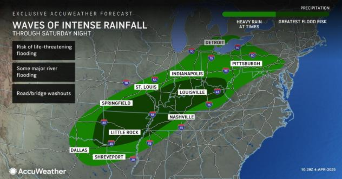
Additional rounds of torrential rain will continue to trigger widespread, life-threatening and catastrophic flash flooding centered on the mid-Mississippi and Ohio valleys into Saturday night, AccuWeather meteorologists warn. In the next few weeks, runoff from the extreme rainfall will result in moderate to major flooding on the secondary and largest rivers in the region.
As of Friday, some locations in Tennessee and Kentucky were approaching double-digit rainfall from an event that was only about halfway complete. Some locations in the mid-Mississippi and Ohio valleys will be on the receiving end of two more rounds of heavy rain with perhaps the most intense coming from Saturday to Saturday night.

The rainfall has already caused scores of flash flood warnings, with runoff inundating some neighborhoods. Many small streams have overflowed banks or soon will at a rapid pace, adding to the danger of severe thunderstorms, some packing tornadoes.
Similar to what happened with Helene in the southern Appalachians, roads and bridges along small streams may be washed away, and small streams can become raging torrents of high water that put lives in peril and wash away homes and vehicles.
In some cases, the rate of rain has overwhelmed, and will continue to overwhelm, storm drainage capabilities. When done, this could end up being a once-in-a-500- to 1,000-year rain event.

Because of the scope of rainfall projected, AccuWeather meteorologists have issued a rare catastrophic flood impact and a massive zone of extreme flood impact. Such a situation has not unfolded since Helene.
When the repeating rounds of rain finally finish later this weekend, a broad area will exist where 8-16 inches of rain has fallen, with local amounts to as high as 20 inches. The AccuWeather Local StormMax™ rainfall for the event spanning Wednesday to Saturday night is 21 inches. The final amount of rain projected is equivalent to two to four month’s worth of rain in the region.

Rain has not fallen evenly across the region, due in part to the orientation of the atmospheric river, or the plume of moisture-rich air originating from the Caribbean and Gulf. However, a more progressive and widespread round of intense rain is forecast from Saturday to Saturday night. This will occur as the caboose in the train of moisture-rich storms moves along.
In some cases, from late Saturday to Saturday night, multiple hours of extreme rain and life-threatening flash flooding may follow the terror of severe thunderstorms with tornadoes from the mid-Mississippi Valley to portions of the Ohio and Tennessee valleys.

Even long after the rain ends in the region from later Sunday on, all the water that gathered in urban areas and small streams will continue to flow and surge into progressively larger rivers in the region.
Flooding on the secondary rivers will be followed by flooding along the largest rivers in the region–the Ohio and lower Mississippi. Moderate to major flooding is forecast along these massive waterways. Some major roads and highways could be underwater for an extended period.
Because water takes many days and weeks to reach a crest then drop below flood stage, some unprotected areas along the Ohio and Mississippi could be underwater for a long period of time. This means that, in some cases, farmland could be inundated or too muddy to access well into the growing season.

The northern cutoff for the high water on the Mississippi is just below St. Louis, as the heaviest rain has and will continue to stay to the south of the major port on the river. However, heavy rain has fallen on the Merrimec River basin just south of St. Louis and is leading to significant flooding.
It may take two to three weeks for the surge of water to cycle to the Mississippi Delta region, including the Atchafalaya flood control zone and later New Orleans. The high and fast-moving water will negatively affect tug and barge operations on the Ohio and lower Mississippi rivers. Due to high water, the tugs will not be able to pull as many barges or may not be able to reach some ports.

As the caboose storm picks up forward speed late Saturday night and Sunday, it will spread much-needed rain to drought and wildfire-ravaged areas of the southern Appalachians and the Carolinas.
While the rate of rain can be heavy in these areas with highly localized flash and urban flooding, the widespread problems over the mid-Mississippi basin should not be repeated.

However, there will be severe weather from Sunday to Monday in the Southeast states. The severe weather risk includes the potential for a few tornadoes.
Want next-level safety, ad-free? Unlock advanced, hyperlocal severe weather alerts when you subscribe to Premium+ on the AccuWeather app. AccuWeather Alerts™ are prompted by our expert meteorologists who monitor and analyze dangerous weather risks 24/7 to keep you and your family safer.