BIRMINGHAM, Ala. (WBRC) – It’s been a busy morning tracking pockets of heavy rain and thunderstorms across Central Alabama. We saw several flash flood warnings for areas along and north of I-20/59. Rainfall totals of 3-5 inches occurred in parts of Lamar, Fayette, and Marion counties. 2-3 inches has been common from Tuscaloosa up towards the Birmingham area. All Flash Flood Warnings have ended (11 a.m. CDT) as the heaviest rainfall remains south of I-20/59. The First Alert Weather Day continues through the afternoon hours for the potential to see pockets of heavy rainfall and a low-end severe threat for Chilton, Coosa, Tallapoosa, and Clay counties. The National Weather Service has issued a Tornado Watch for Coosa, Tallapoosa, and Clay counties until 6 p.m. CDT. The watch extends into southeast Alabama and into parts of North and Central Georgia. Areas in the watch will need to monitor the weather and have ways to receive warnings in case they are issued. The threat for severe weather remains low, but it is not zero. Damaging winds up to 60 mph, large hail up to quarters, and an isolated tornado can’t be ruled out.

The National Weather Service has issued a Tornado Watch for Coosa, Tallapoosa, and Clay counties until 6 p.m. CDT.(WBRC)
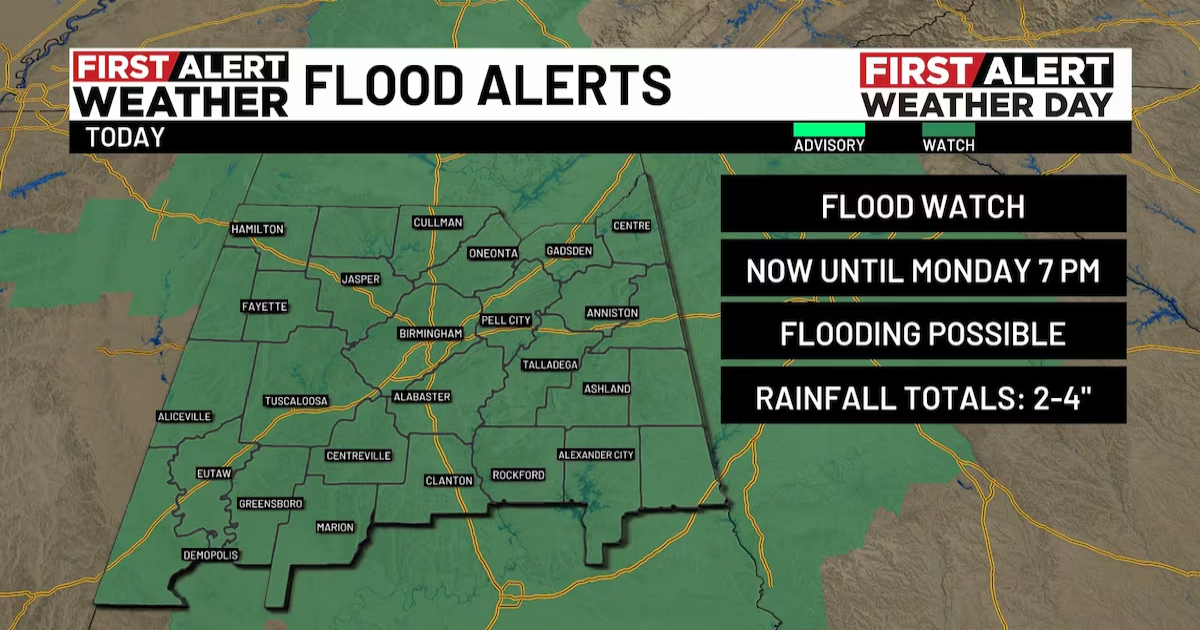
A Flood Watch has been issued for all of Central Alabama until Monday evening at 7 p.m. CDT. The greatest chance for heavy rainfall will occur this morning and into the afternoon hours. The rain will likely shift along and south of I-20/59 as we go into the evening and overnight hours. Rainfall totals could easily add up around two to four inches with higher totals possible in Northwest Alabama. Remember to never drive through flooded areas. Turn around, don’t drown.
The most active weather today will likely remain along and south of I-20/59. We will likely see occasional showers at various times today with temperatures in the mid to upper 60s. The biggest threat will be pockets of heavy rain and the potential to see flooding. We are waiting to see if the line of storms impacting Southeast Alabama will advance to the east. If it somehow slows down and barely moves, the flood threat could really ramp up in parts of Chilton, Coosa, Tallapoosa, Clay, Cleburne, Randolph, and Chambers counties. My best advice is to avoid traveling into Georgia and southeast Alabama this afternoon and evening. The severe threat should end for all of Central Alabama by the early evening hours. We will likely remain cloudy this evening and tonight with a 40% chance for spotty showers. Temperatures should remain in the 60s this evening and cool into the 50s overnight. No severe weather is expected tonight or into Monday morning.
Cool temperatures Monday: Showers will be possible tonight into Monday morning for areas along and south of I-20. Temperatures will likely cool into the lower 50s Monday morning. Most of the moisture should move out of our area by Monday afternoon. We will remain mostly cloudy tomorrow with temperatures remaining in the mid to upper 50s. You’ll definitely want to grab the jacket. Winds will likely come from the northwest tomorrow at 5-15 mph.
Dry and sunny Tuesday: With dry air and clouds decreasing Monday night, temperatures are forecast to cool into the lower 40s Tuesday morning. Upper 30s can’t be ruled out for areas north of Birmingham. Tuesday afternoon should be gorgeous with plenty of sunshine. High temperatures are forecast to warm into the lower 60s Tuesday afternoon. The air will be dry, so humidity will not be a factor early this week.

Next 24 hours(WBRC)
First Alert for potential frost Wednesday morning: We want to give you a first alert for the potential to see chilly temperatures Wednesday morning. You may want to cover up or bring your plants inside Tuesday evening as temperatures cool into the mid to upper 30s. Wednesday morning will end up very chilly, but we should see temperatures rebound into the upper 60s Wednesday afternoon with a mostly sunny sky.

Low Temperatures(WBRC)
Rain returns Thursday evening: Our next chance to see showers and perhaps an isolated thunderstorm will likely occur Thursday evening into Friday morning. A fast-moving cold front will likely produce scattered showers across the northern half of Alabama Thursday evening. Rain will likely move through Central Alabama Thursday night and exit by the mid and late morning hours of Friday. Behind this cold front, we could see temperatures cool back into the mid to upper 60s Friday afternoon. Morning temperatures could drop into the lower 40s Saturday morning. Next weekend is looking sunny and dry. Good news for all outdoor plans!
Be sure to check in for updates on the WBRC First Alert Weather app. You can download our app on Android and Apple devices for the latest weather updates.
Get news alerts in the Apple App Store and Google Play Store or subscribe to our email newsletter here.
Copyright 2025 WBRC. All rights reserved.