NEW YORK – Dangerous flash flooding is beginning along the Interstate 95 corridor on Thursday as millions of people in the Northeast and mid-Atlantic are bracing for rounds of severe weather and flooding rain on Thursday as a cold front sweeps across the region and brings some much-needed relief from the relentless heat.

(FOX Weather)
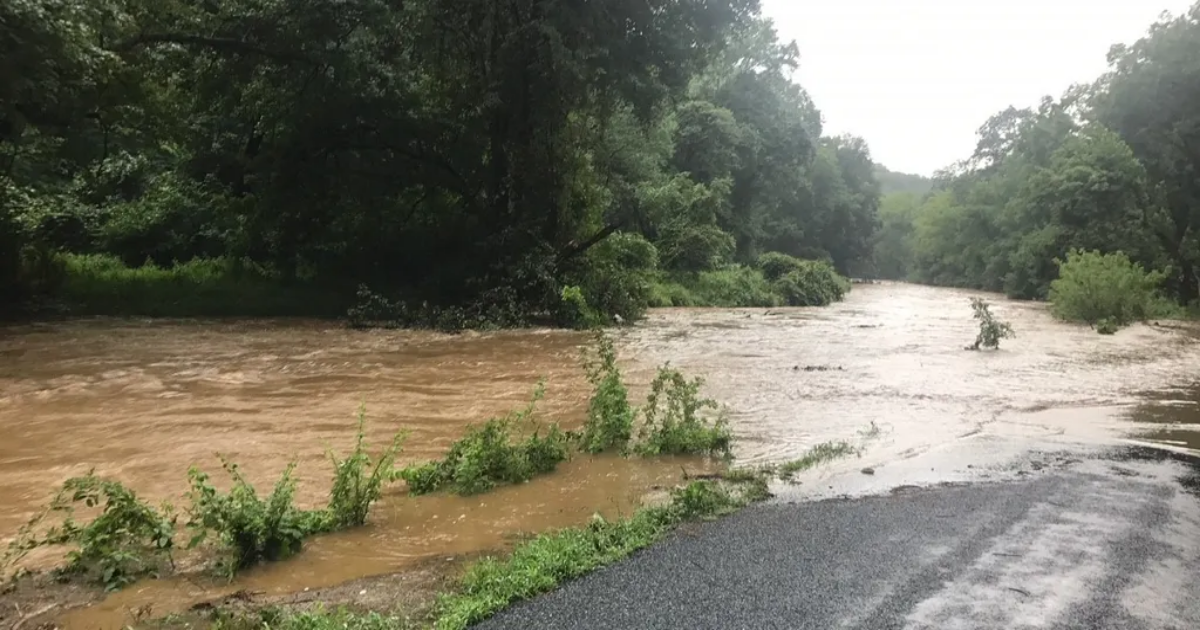
The threat of flash flooding materialized early Thursday afternoon in Maryland with water rescues reported in the Joppatowne area of Harford County, north of Baltimore. By 2:15 p.m. between 2 and 4 inches of rain had fallen northeast of Baltimore, according to the National Weather Service Baltimore-Washington office.
The flooding potential is expected to increase during the day as storms develop during the afternoon hours, some of which could be severe. A Severe Thunderstorm Watch is in place from Northern Virginia to New York City through Thursday night.
New York City Mayor Eric Adams took to social media on Thursday morning and urged his residents to be prepared for flooding.
“New Yorkers, be prepared for a serious storm to arrive later this afternoon,” he said on X. “A Flood Watch begins at 2 p.m., and we’ve issued a Travel Advisory for today and tomorrow. Avoid traveling if you can, and set up flood prevention tools in advance.”
After the latest forecast called for up to 7 inches of rain in some areas, New Jersey Acting Gov. Tahesha Way declared a state of emergency for all of New Jersey beginning at 2 p.m.
“Beginning this afternoon, we are expecting severe thunderstorms to bring heavy rainfall and damaging wind gusts with the potential for flash flooding across the state,” Way said. “I urge all New Jerseyans to remain alert, follow all safety protocols, and monitor the proper channels for the duration of these storms. Residents should remain off the roads and indoors unless absolutely necessary.”
This latest flooding threat comes two weeks after deadly flooding claimed two lives in New Jersey when a vehicle was swept into a raging brook. During that storm, New York City experienced its second-wettest hour on record with 2.07 inches and shattering a 117-year-old daily record.
Delays are also mounting at airports across the Northeast due to thunderstorms, including Philadelphia International Airport, John F. Kennedy International Airport, LaGuardia Airport, Newark Liberty International Airport and Boston Logan International Airport.
 This graphic shows forecast rain totals through Friday, Aug. 1.
(FOX Weather)
The torrential rain will be concentrated along a strong, but slow-moving, cold front, with additional enhancement from an area of low pressure developing along the front.
Rain rates could reach up to 3 inches per hour, which could then lead to flash flooding.
The FOX Forecast Center said that given the atmospheric conditions in place, the most intense storms could bring several inches of rain in a short period of time.
In total, rain amounts of 2-4 inches are likely in many areas, with locally higher amounts of 5-8 inches possible.
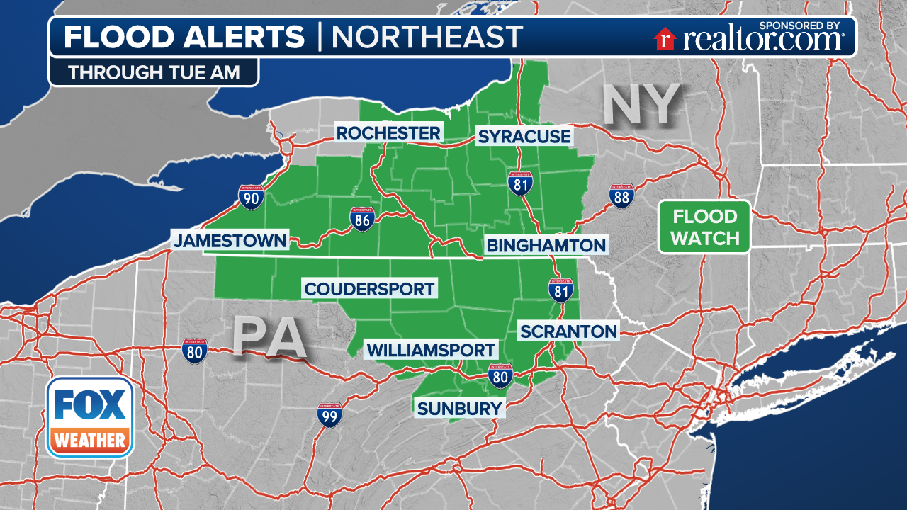
Because of the threat of heavy rain and flooding, Flood Watches have been posted across the region.
(FOX Weather)
Flood Watches are in effect from Virginia to Connecticut, including cities like Washington, Philadelphia and New York City.
The FOX Forecast Center said that there is high confidence that multiple inches of rain will fall where those storms linger the longest, but confidence remains low regarding exactly where that will occur.
Computer forecast models show a corridor from Washington to Philadelphia to New York City, including much of eastern Pennsylvania and New Jersey, as the area where flooding will be most likely to occur.
 This graphic shows the flood threat on July 31, 2025.
(FOX Weather)
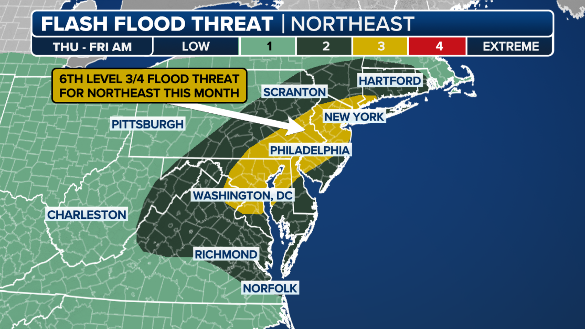
NOAA’s Weather Prediction Center (WPC) placed the area in a Level 3 out of 4 flood risk on Thursday, which includes about 23 million people.
So far in July, portions of the Northeast have been in a Level 3 out of 4 flood risk six times.
And if flooding wasn’t enough to be concerned about, severe weather is also possible across portions of the mid-Atlantic and Northeast.

(FOX Weather)
NOAA’s Storm Prediction Center (SPC) placed portions of Pennsylvania, New Jersey, Delaware, Maryland, Washington and Virginia in a Level 2 risk on its 5-point severe thunderstorm risk scale.
The FOX Forecast Center said that thunderstorms are expected to quickly develop in the afternoon due to surface heating along with dew points in the 70s.
Most of the storms are expected to develop in clusters, but there is a threat of some developing into supercell thunderstorms.
The main threat from storms that develop will be damaging wind gusts higher than 60 mph, as well as some large hail.