![]() Updated on: July 7, 2025 / 8:58 AM EDT / CBS Baltimore
Updated on: July 7, 2025 / 8:58 AM EDT / CBS Baltimore
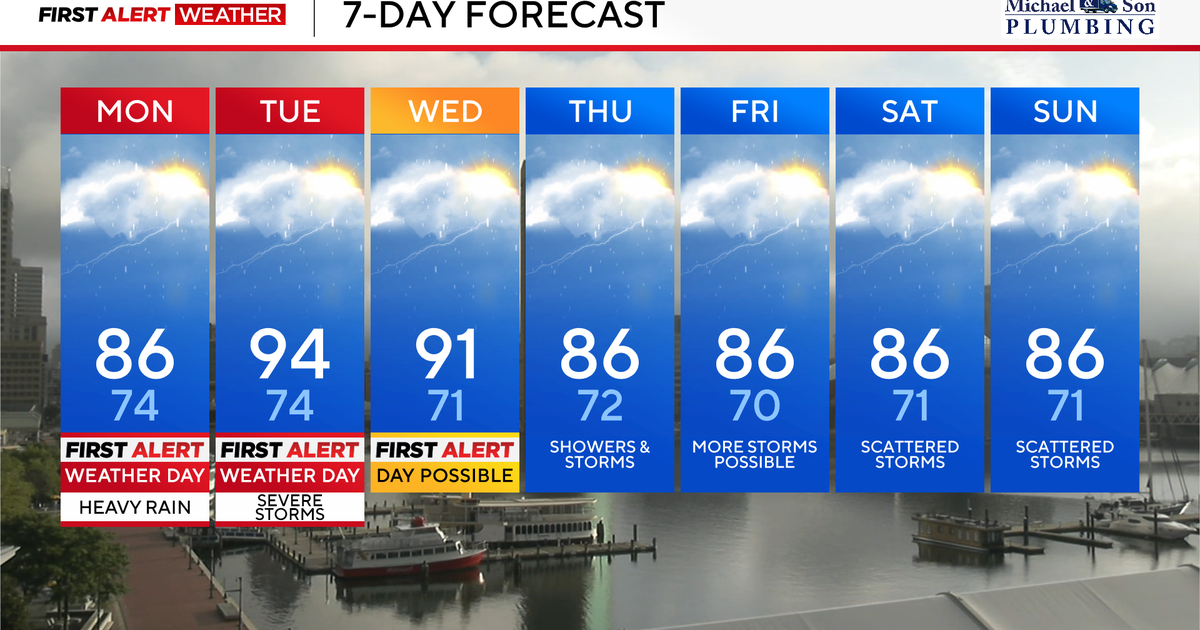
Hot and muggy air will fuel severe weather and thunderstorms in Maryland Monday morning through the afternoon hours, especially areas along and east of I-95.
Any of these downpours could cause flash flooding with Flood Watches in effect.
More showers and strong to severe thunderstorms will impact more of our area Tuesday and Wednesday afternoon and evening, potentially bringing more travel disruptions.
Flood Watches in Maryland
Monday is a WJZ First Alert Weather Day for the possibility of heavy rain and flash flooding, mainly for communities along and east of Interstate 95.
A Flood Watch has been issued for southeastern areas of Baltimore and Harford counties along with all of Anne Arundel, Cecil, Kent, Queen Anne’s, Caroline, and Talbot counties from late morning through this evening for the potential of flash flooding. If you see flood waters, turn around, don’t drown.
This air will be tropical and heavy today with with spotty hit-or-miss heavy rain showers through the morning commute.
Rain showers and thunderstorms will become more numerous mid to late morning through the afternoon and evening hours. Rainfall rates in any of the heavier showers and storms could range from 2 to 3 inches per hour.
Not every neighborhood will get one of these storms, but areas that do need to be aware of rapidly changing weather conditions. Areas that receive repetitive thunderstorms today could see upwards of 5″ of rain.
The greatest chance of rain remains east of I-95 between 11 a.m. and 6 p.m. Rain quickly diminishes and shifts out of our area by early evening with just a leftover thunderstorm possible north and west toward evening.
Areas north and west of I-95 today will be much drier than areas along and east of it. Temperatures today will be warm and muggy with highs in the middle to upper 80s.
Stormy weather possible Tuesday and Wednesday
More heavy rain and strong thunderstorms are likely Tuesday afternoon and evening. Additional strong to severe storms are also possible Wednesday. Tuesday has been upgraded to a First Alert Weather Day for the potential of strong to severe storms from 2 p.m. until 8 p.m.
Given saturated grounds from recent showers and thunderstorms along with tropical humidity in place, the table is set for more potential flash flooding on Tuesday afternoon and evening. Saturated grounds and strong thunderstorm wind gusts may also knock down some trees and powerlines.
A similar scenario may play out on Wednesday, especially during the afternoon and evening. Scattered to numerous thunderstorms will develop during the afternoon and evening hours with an additional flash flood and wind damage threat. We will continue to monitor the latest day for Wednesday and may upgrade it to a First Alert Weather Day.
Both days will be very hot and muggy with highs in the lower to middle 90s and feels like temperatures in the 100s.
Heat, humidity and storms for the weekend
More showers and thunderstorms will be boiling up along a stalled frontal boundary across our area. While a shower or thunderstorm could pop up at just about any time, the best chances for showers and storms will be during the afternoon and evening hours.
When it’s not raining, expect variable clouds, warm, and tropical humidity. Highs in the middle to upper 80s with feels like temperatures in the lower 90s.
Stay with the First Alert Weather Team for more updates on possible additional severe weather watches and warnings over the upcoming week.