That was not your imagination. Two earthquakes in less than a week have rattled more than the ground across North Jersey.
Whenever an earthquake strikes, many may wonder what caused the earthquake and how strong it was compared to others in the state or worldwide. Here are what the experts say about the science behind an earthquake.
What causes an earthquake?
An earthquake occurs because of slippage between the earth’s tectonic plates, according to the U.S. Geological Survey.
The edges of the plates, or plate boundaries, are made up of many faults, and most earthquakes occur on these faults. “Since the edges of the plates are rough, they get stuck while the rest of the plate keeps moving,” according to the USGS. “Finally, when the plate has moved far enough, the edges unstick on one of the faults and there is an earthquake.”
In New Jersey and elsewhere, earthquakes usually occur “when slowly accumulated strain within the Earth’s crust is suddenly released along a fault,” according to “Earthquake Risk in New Jersey,” a publication of the New Jersey Geological Survey.
Is it covered?: Is earthquake damage covered by homeowners insurance in New Jersey? Here’s the answer
“The energy from this movement travels as seismic waves along the ground surface and within the earth,” the publication says.
The earthquake waves are caused by the release of energy as the Earth’s plates move, said Dr. Matthew Gorring, an associate professor of Earth and Environment Studies at Montclair State University.
The surface where that slippage occurs is called a fault.
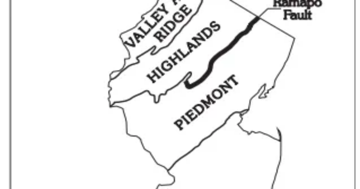
While there are many faults in New Jersey, the best known is the Ramapo Fault, which runs northeast-southwest in North Jersey. The majority of New Jersey’s quakes occurred around this fault area.
History: A look back at earthquake history in New Jersey
The Ramapo Fault system runs from southeastern New York to eastern Pennsylvania, according to the earth Institute at Columbia University. “These faults were active at different times during the evolution of the Appalachians, especially in the Mesozoic when they served as border faults to the Newark Basin and other extensional basins formed by the opening of the Atlantic Ocean approximately 200 million years ago.”
In New Jersey, fault lines do not generally break the Earth’s surface, but are based several miles below.
Earthquakes east of the Rockies are generally less intense than to the west, but because of geologic differences, eastern earthquakes tend to affect areas 10 times larger than western ones of the same magnitude, according to the New Jersey Geological Survey.
The location below the earth’s surface where the earthquake starts is called the hypocenter and the location directly above it on the surface of the earth is called the epicenter.
How major is a 2.7 earthquake?
Earthquakes are recorded using seismographs and magnitude measures the strength of an earthquake. A 2.7 earthquake like the one on Aug. 5 usually calculates minor to no damage to the surrounding areas.
As the magnitude increases by one whole number, the size of the earthquake increases by a factor of 10. So an earthquake that measures a magnitude of 5.0 would result in 10 times more ground shaking than one with a magnitude of 4.0. — and about 32 times as much energy would be released.
According to a New Jersey Office of Emergency Management report, “New Jersey is in an area where the rarer plate interior-related earthquakes occur. As plates continue to move and plate boundaries change geologically over time, weakened boundary regions become part of the interiors of the plates. These zones of weakness within the continents can cause earthquakes in response to stresses that originate at the edges of the plate or in the deeper crust.”