AUSTIN (KXAN) — Search and rescue operations continue across Central Texas after “catastrophic” flooding hit the region. At least six people are dead and several others remain missing.
Here are the top headlines:
- A Flash Flood Warning remains in effect for Lampasas County until 8:30 p.m.
- Four deaths have been confirmed and 10-13 people are missing in Travis County, according to County Judge Andy Brown
- Two deaths have also been confirmed in Burnet County. Crews there are currently searching for Marble Falls Area VFD Chief Michael Phillips, who was swept away in flood waters. A person from a nearby nursing home is also missing.
- At least 43 people are confirmed dead in Kerr County, including 15 children. Another 27 people are still missing.
- Three people are missing in Williamson County, and more than 100 people have been displaced in the county. Evacuations are in effect in Georgetown for residents of mobile home parks along the San Gabriel River.
- A boil water notice has been issued for some neighborhoods in Georgetown due to a water main break.
- A local disaster declaration has been issued in both Travis and Williamson counties. Dozens of people have been rescued from high water in both counties.
- Flood operations are underway at Inks, Wirtz, Starcke and Tom Miller dams, as well as at Lake Bastrop. The LCRA does not anticipate flood operations at Mansfield and Buchanan dams at this time.
- A watercraft ban has been issued on all City of Austin waterways until noon Monday, including Lady Bird Lake and Lake Austin.
- More than 100 low water crossings are closed across the area, including FM 1431 near Lago Vista, where the road was partially washed out.
- Gov. Abbott called the damage “nothing more than extraordinary devastation.” He said crews will be “relentless in going after every single person that has been a victim in this event,” adding that operations are continuing day and night.
- Why were flash floods across Central Texas so catastrophic? Read Meteorologist Freddy Vela’s weather blog post.
7:24 p.m.: Three people remain missing in Williamson County, according to an update from county officials. Crews rescued 26 people from floodwaters in the county. The Hope House in Liberty Hill was evacuated by helicopter, with assistance from Fort Hood.
7:00 p.m.: The Flash Flood Emergency for parts of Burnet, Travis and Williamson counties has expired. There are two Flash Flood Warnings remaining in effect:
- Northeastern Blanco and southern Burnet counties until 7:15 p.m.
- Northern Blanco, southwestern Burnet and southeastern Llano counties until 7:15 p.m.
- Lampasas County until 8 p.m.
6:53 p.m.: The American Red Cross has established a Family Assistance Center hotline to help people trying to find missing family members in Travis County, in the Sandy Creek area. If you need help, call 1-800-733-2767.
6:43 p.m.: The Flash Flood Warning for northeastern Blanco and southern Burnet counties has been extended until 7:15 p.m.
6:41 p.m.: KXAN’s Grace Reader spoke with a man who helped save a family from rising floodwater in Jonestown overnight.
“It’s kind of like, you know, the worst nightmare you’ve ever had, and just kind of realizing that in the moment is something that, if you haven’t gone through it, it’s really kind of hard to comprehend,” Matthew Crowder said.
6:26 p.m.: Kerr County officials confirm 43 people have been killed in flooding in the county, including 15 children.
6:23 p.m.: The Lower Colorado River Authority says Lake Travis has now risen 16′ since Friday morning and is expected to continue to rise. Lake Buchanan has risen 2′ since Friday and is expected to rise at least 7′ more over the next few days.
This video, taken by KXAN’s Avery Travis, shows a floodgate partially opened at Tom Miller Dam, allowing water to flow from Lake Austin to Lady Bird Lake.
6:18 p.m. Photos and video from KXAN photojournalist Todd Bailey shows a raging San Gabriel River, seen from the SH 29 bridge near Georgetown.

 A flooded San Gabriel River, seen from the SH 29 bridge near Georgetown, Texas, on July 5, 2025. (KXAN Photo/Todd Bailey)
6:10 p.m.: Travis County Judge Andy Brown says there are now four confirmed deaths in Travis County.
6:08 p.m.: Gov. Greg Abbott has declared Sunday a “Day of Prayer in Texas” in response to the flooding.
“Texans are known for their faith, strength and resilience,” Abbott said. “Even as floodwaters raged, neighbors rushed in to rescue, comfort and bring hope. In times of loss, we turn to God for comfort, healing and strength. I urge every Texan to join me in prayer this Sunday — for the lives lost, for those still missing, for the recovery of our communities and for the safety of those on the front lines.”
6:07 p.m.: The Flash Flood Warning in northern Blanco, southwestern Burnet and southeastern Llano counties has been extended until 7:15 p.m.
5:40 p.m.: The number of people killed in Travis County has risen to three, according to Travis County Judge Andy Brown. County officials say around 13 people are still missing, but that number could change.
5:33 p.m.: Austin Pets Alive! says they’ve received more than 60 animals from shelters in Kerr and Williamson counties. The Kerr County shelter was completely cleared out, allowing them to house lost pets closer to home. Anyone who can help with fostering is asked to go to the APA! website.
5:31 p.m.: A new Flash Flood Warning has been issued for Lampasas County until 8:30 p.m.
5:30 p.m.: Some Austin ISD families were impacted by the floods in Kerr County, Supt. Matias Segura said in a letter to parents.
“We know that some of our families and staff may be facing loss or uncertainty, and we are coordinating with our crisis and counseling team to provide support and any needed services to our families and staff in the days ahead,” Segura said.
The district is asking anyone affected by flooding to contact their campus principal so support can be provided. Families can also request individualized services from the district’s counseling and mental health team.
5:15 p.m.: The Flash Flood Warning for central Travis County has been extended until 7 p.m. Considerable damage is still possible, the National Weather Service warns.
5:13 p.m.: Photos from KXAN’s Sam Stark shows extensive flooding at the Shady River RV Resort along the San Gabriel River near Georgetown.
 Extensive flooding at Shady River RV Resort in Georgetown, Texas, on July 5, 2025. (KXAN Photo/Sam Stark)
 Extensive flooding at Shady River RV Resort in Georgetown, Texas, on July 5, 2025. (KXAN Photo/Sam Stark)
 Extensive flooding at Shady River RV Resort in Georgetown, Texas, on July 5, 2025. (KXAN Photo/Sam Stark)
 Extensive flooding at Shady River RV Resort in Georgetown, Texas, on July 5, 2025. (KXAN Photo/Sam Stark)
5:05 p.m.: Video shows a swollen Shoal Creek near S. Lamar Boulevard in central Austin:
4:39 p.m.: At least three people are missing in Williamson County, County Judge Steven Snell told KXAN’s Sam Stark. More than 100 people have been displaced by flooding in the county.
4:35 p.m. The Flash Flood Warning in northeastern Blanco and southern Burnet counties has been extended until 7 p.m.
4:34 p.m.: Tonight’s Austin FC game versus LAFC has been postponed due to weather.
“Austin FC extends its heartfelt sympathy to those who have been impacted by the devastating flooding across Central Texas,” a post on social media read.” Our hearts go out to the families, friends and neighbors who have lost their lives – and we urge those that are able to find their way to safety. We also want to express our gratitude and respect for those who are responding to the crisis with life saving measures.”
4:21 p.m.: The LCRA is partially opening a floodgate at Tom Miller Dam, which connects Lake Austin to Lady Bird Lake. The agency said flows throughout the Highland Lakes are higher and faster than usual and urged nearby residents to protect people and property that might be affected by water releases.
KXAN Meteorologist Tommy House captured this photo from our Austonian camera showing flooded trails along Lady Bird Lake before the Tom Miller Dam floodgate was opened.

A floodgate at Lake Bastrop was also partially opened, releasing water down Spicer and Piney creeks to the Colorado River.
The LCRA said it does not anticipate opening floodgates at Mansfield Dam, which forms Lake Travis. Instead, floodwater moved downstream from Inks Lake, Lake LBJ and Lake Marble Falls will be held in Lake Travis.
4:17 p.m.: A boil water has been issued in Georgetown for neighborhoods near Interstate 35 “out of an abundance of caution.” A water main break, likely connected to flooding, may cause customers to have low or no pressure, a press release from the city said.
Neighborhoods affected include North Old Town/North Addition, Parkview Estates, Katy Crossing, Stillwater, Crystal Knoll, Villages of Berry Creek, Golden Oaks, Reatta Trails, Country Club and Rivery.
Water for drinking, cooking and ice making should be brought to a vigorous, rolling boil for two minutes and cooled prior to use.
The video below shows flooding at Waters Edge Apartment Homes in Georgetown, which were evacuated earlier in the day:
4:10 p.m.: Liberty Hill ISD is sending some counseling staff to Alamo Heights ISD, which had more than 300 students at Camp Mystic when flood waters rose early Friday morning. Several people remain missing as of Saturday afternoon.
“Our thoughts go out to everyone who has been affected by the rain, high waters, damage and loss of loved ones,” the district said in an email to parents. “We grieve with those families trying to navigate this awful time of loss and lift them up with our prayers.”
4:03 p.m.: Tonight’s Round Rock Express game at the Dell Diamond has been postponed due to weather. The game against the Sugar Land Space Cowboys will be made up in September. Ticket holders will receive an email with instructions on how to exchange them for any other game this season.
3:40 p.m.: Kerr County Sheriff Larry Leitha said 32 people have been killed and 27 others are still missing in the county. Of those killed, 18 are adults and 14 are children. Five adults and three children remain unidentified at this time.
“The entire river is being searched, from the northern-most all the way down,” Texas Division of Emergency Management Chief Nim Kidd said. “That process is going to keep going. We are not stopping until we find everyone that is missing.”
Kidd said 1,331 additional state personnel are helping local responders. There are more than 900 state assets on the ground, including from TDEM, DPS, TxDOT, TPWD, the Texas Military department and the Texas A&M Forest Service.
3:39 p.m.: A new Flash Flood Warning has been issued for northern Burnet County until 7 p.m. “Considerable” damage is possible in this area, the National Weather Service says.
3:31 p.m.: The Flash Flood Emergency in southwestern Burnet County, northwestern Travis County and western Williamson County has been extended until 7 p.m. The National Weather Service continues to call this a “particularly dangerous situation,” adding that “catastrophic” damage is possible.
3:27 p.m.: A disaster declaration has been issued in Travis County. “The flooding we’re seeing in parts of western Travis County is devastating,” Judge Andy Brown said. “Under my direction, the Travis County Office of Emergency Management is doing everything in our power to support search and rescue efforts and ensure the safety of our residents. We have activated all available emergency resources and will continue working closely with state and local partners to help those affected recover from this disaster.”
Crews have responded to approximately two dozen water rescues throughout the county as of this afternoon.
3:25 p.m.: Gov. Abbott said in the past 36 hours, more than 850 people have been rescued from floodwaters, “some clinging to trees.”
3:22 p.m.: The Flash Flood Warning in central Travis County has been extended until 6 p.m. The National Weather Service continues to warn of the threat of “considerable” damage.
3:20 p.m.: Homeland Security Secretary Kristi Noem said whatever federal resources are needed will be provided, adding that the Federal Emergency Management Agency is “standing at an enhanced level now.” Coast Guard assets have also been deployed to help, including fixed-wing aircraft and helicopters to aid in search and rescue efforts.
NBC News gathered this video showing the devastation in Kerrville:
3:17 p.m.: KXAN’s Eric Henrikson reports from Nameless Road, north of Lake Travis, off of FM 1431. The area received damage overnight from the floods. The Big Sandy Creek area at one point was receiving between 3 to 6″ of rain per hour. Damage included downed power lines, toppled trees and chunks of asphalt torn from the street.
Much of the floodwater is flowing into Lake Travis. According to LCRA data, as of 3 p.m. Lake Travis has risen above 652′ above mean sea level. That is up more than 14′ from the same time on Friday. The lake is considered full when the water level reaches 681′ msl.
3:15 p.m.: In a press conference in Kerrville, Gov. Greg Abbott said the flooding across Central Texas has caused “nothing more than extraordinary devastation.” Abbott said crews will be “relentless in going after every single person that has been a victim in this event,” adding that operations are continuing day and night.
3:12 p.m.: A new Flash Flood Warning has been issued for northern Blanco County, southwestern Burnet County and southeastern Llano County until 6:15 p.m. “Considerable” damage is possible in this area, the National Weather Service says.
3:09 p.m.: The National Weather Service says very heavy rain continues to fall between Llano and Travis counties. A rain gauge in Marble Falls reported 3.32″ in just the past hour.
3:00 p.m.: The City of Austin has issued a watercraft ban on all city waterways until noon Monday. This includes the use of personal and commercial watercraft, wet bikes, motorized surfboards, canoes, kayaks, paddleboards and similar devices. The ban includes Lady Bird Lake, Lake Austin, the Colorado River downstream of Longhorn Dam, Barton Creek and Bull Creek.
“Rainfall has created high and swift waters which, combined with debris, has made recreational, commercial and navigational use of area waterways within the City of Austin unsafe,” Mayor Kirk Watson said in a social media post. Watson also cautioned against using riverfront trails.
2:45 p.m.: Two people are confirmed dead and two others are missing in Burnet County, the sheriff’s office confirmed to KXAN’s Arezow Doost. Search and rescue operations are currently taking place along FM 1431.
2:40 p.m.: KXAN Meteorologist Freddy Vela just posted a new weather blog detailing why the flooding has been so catastrophic.
2:25 p.m.: Before a planned 2:30 p.m. news conference, Gov. Abbott is meeting outside the building in Kerrville with Homeland Security Sen. John Cornyn, Homeland Security Secretary Kristi Noem, Congressman Chip Roy and Chief of the Texas Division of Emergency Management Nimm Kidd.
2:23 p.m.: The Flash Flood Warning in southwestern Williamson County has been canceled and replaced with a Flood Advisory. “The heavy rain has ended,” the National Weather Service said. “Flooding is no longer expected to pose a threat. Please continue to heed remaining road closures.”
2:15 p.m.: Austin-Travis County EMS said it responded to a water rescue call around 2 a.m. in the Sandy Creek neighborhood in northwestern Travis County. A family was trapped in their home due to rising flood waters, and rescue efforts were complicated due to impassible roads, EMS said.
“ATCEMS boat teams eventually made access to the area and found dozens of people in need of help, clinging to trees, power poles, and on rooftops,” EMS said.
A total of 25 people were evacuated from the area, and 10 were taken to a Family Assistance Center. Medics transported four people to local hospitals with minor injuries.
2:12 p.m.: This video from Quentin Rudzik shows rushing water overwhelming a low water crossing near County Road 341 and County Road 340, northeast of Marble Falls. As of now, ATXFloods.com has 114 crossings listed as closed due to high water.
2:08 p.m.: A new Flood Watch is now in effect for Bastrop, Blanco, Burnet, Caldwell, Fayette, Gillespie, Hays, Lee, Llano, Travis and Williamson counties until 10 p.m. The National Weather Service warns that excessive runoff may result in flooding of rivers, creeks, streams and other low-lying and flood-prone areas.
2:04 p.m.: The Flash Flood Warning in southwestern Caldwell County has been canceled and replaced with a Flood Advisory. “The heavy rain has ended,” the National Weather Service said. “Please continue to heed remaining road closures.”
2:00 p.m.: The Lower Colorado River Authority is “strongly encouraging” people to stay off Lake Travis, Lake LBJ and Lake Marble Falls over the next few days to avoid flood debris, fast-moving flows and bacteria levels and usually increase after flooding.
“We want people to stay safe, and the wise decision under these conditions is to avoid being on these lakes at this time,” LCRA Executive Vice President of Water John Hofmann said. “This is especially important at night when visibility is reduced, as some of the navigational buoys that help guide boaters have been damaged or destroyed in the flooding.”
1:59 p.m. Photos from KXAN’s Grace Reader showed part of Nameless Road in northwestern Travis County washed out.
 Flood damage along Nameless Road in northwest Travis County on July 5, 2025. (KXAN Photo/Grace Reader)
 Flood damage along Nameless Road in northwest Travis County on July 5, 2025. (KXAN Photo/Grace Reader)
 Flood damage along Nameless Road in northwest Travis County on July 5, 2025. (KXAN Photo/Grace Reader)
 Flood damage along Nameless Road in northwest Travis County on July 5, 2025. (KXAN Photo/Grace Reader)
 Flood damage along Nameless Road in northwest Travis County on July 5, 2025. (KXAN Photo/Grace Reader)
 Flood damage along Nameless Road in northwest Travis County on July 5, 2025. (KXAN Photo/Grace Reader)
1:55 p.m. KXAN Photojournalist Frank Martinez took these photos showing an incredible amount of damage from the flooding in Kerrville.
 Flooding damage in Kerrville, Texas, on July 5, 2025. (KXAN Photo/Frank Martinez)
 Flooding damage in Kerrville, Texas, on July 5, 2025. (KXAN Photo/Frank Martinez)
 Flooding damage in Kerrville, Texas, on July 5, 2025. (KXAN Photo/Frank Martinez)
 Flooding damage in Kerrville, Texas, on July 5, 2025. (KXAN Photo/Frank Martinez)
 Flooding damage in Kerrville, Texas, on July 5, 2025. (KXAN Photo/Frank Martinez)
1:46 p.m.: Ongoing water rescues are underway along FM 1431 near Faith Academy in Marble Falls. Crews are currently searching for Chief Michael Phillips with the Marble Falls Area Volunteer Fire Department, as well as a person from a nearby nursing home, according to the Burnet County Sheriff’s Office. BCSO previously told KXAN a firefighter had been “swept away” during a rescue.
1:42 p.m.: A new Flash Flood Warning has been issued for northeastern Blanco County and southern Burnet County until 5 p.m. The National Weather Service says there is the potential for “considerable” damage.
1:35 p.m.: As of now, 106 low water crossings are closed across Central Texas, according to ATXFloods.com. Here’s a look at some of the conditions at crossings around the area:
 Walnut Creek at Waters Park closed due to water over road
 Bull Creek at Spicewood closed due to water over road
 Bull Creek at Spicewood closed due to water over road
 Bull Creek at Spicewood closed due to water over road
 Bull Creek at Spicewood closed due to water over road
1:30 p.m.: The Flash Flood Warning for central Travis County has been extended until 4 p.m. Life-threatening flash flooding is occurring, and the National Weather Service warns of the potential for “considerable” damage.
1:28 p.m.: The Flash Flood Warning in southwestern Hays County has been canceled. “Flooding is no longer expected to pose a threat,” the National Weather Service said.
1:27 p.m.: Several state parks are closed across the region due to flooding, according to the Texas Parks and Wildlife Department. The following parks are closed:
- Inks Lake State Park
- Lost Maples State Natural Area
- Old Tunnel State Park
- Colorado Bend State Park
Before visiting a park, you’re asked to check the park’s website for any alerts, as well as weather and road conditions. “Conditions can change quickly, and even familiar trails or river access points may now be unsafe,” TPWD said. “Your safety is our top priority.”
1:18 p.m. Photos from KXAN’s Grace Reader shows extensive flooding at Cold Springs Hollow in the Travisso neighborhood.
 Flooding at Cold Springs Hollow in the Travisso neighborhood in Leander, Texas, on July 5, 2025. (KXAN Photo/Grace Reader)
1:14 p.m.: The Flash Flood Emergency for Burnet, northwestern Travis and northwestern Williamson counties has been extended until 4 p.m. The National Weather Service calls this a “particularly dangerous situation” and says “catastrophic” damage is possible.
1:09 p.m.: Flood operations are underway at Inks, Wirtz and Starcke dams, according to the Lower Colorado River Authority. The LCRA said it does not anticipate flood operations at Mansfield, Buchanan and Tom Miller dams at this time.
1:00 p.m.: “We literally had homes that were washed away. We had people trapped in homes,” Travis County ESD 1 Chief Donnie Norman told KXAN. he Sandy Creek area has been hit hardest in Travis County. That’s the area where most of the missing 10 people in the county are from. Among the missing is a 17-year-old girl.
12:28 p.m.: KXAN’s Dylan McKim reports from San Antonio Street in Center Point (Kerr County), where crews are cleaning up flood debris on a highway bridge. Workers are removing piles of tree branches and splintered wood, and finding personal items, like shoes, in the debris. A home, forced from its foundation in the flood, sits along the bridge.
12:19 p.m.: The Flash Flood Warning for southwestern Hays County has been extended until 2 p.m. The National Weather Service says “considerable” damage is possible.
12:15 p.m.: Two deaths have been confirmed and 10 people are missing in Travis County, according to Donnie Norman, the chief of Travis County Emergency Services District 1. Further details were not immediately available. KXAN is working to confirm more information.
 Flooding in Lago Vista (KXAN photo/Grace Reader)
 Road closures in Lago Vista (KXAN photo/Grace Reader)
12:05 p.m.: The Flash Flood Warning for southwestern Caldwell County has been extended until 3 p.m. The National Weather Service says “considerable” damage is possible.
12:05 p.m.: Lake level update: Lake Travis is 650.54′ above mean sea level. That is up 13′ over the past 24 hours. The lake is considered full when the water level reaches 681′ msl.
11:59 p.m.: A local disaster declaration has been declared in Williamson County. Judge Steve Snell issued the declaration “to protect health, safety and welfare of county residents.”
The county’s Office of Emergency Management activated its Emergency Operations Center at 5 a.m. to coordinate resources and request assistance from the state.
Up to 25 people have been rescued from swift water, the county said — the majority of those were rescued from homes. Another 16 people were evacuated from Hope House in Liberty Hill.
11:55 a.m.: The Williamson County Regional Animal Shelter said it has an urgent need for foster help due to the emergency evacuation of the shelter in Georgetown. The shelter is at capacity for dogs and almost at capacity for cats. The shelter says it needs fosters for 85 cats and 35 dogs.
Anyone who can help is asked to come to the shelter as soon as possible between 12 p.m. and 6 p.m. The shelter is located at 1855 SE Inner Loop in Georgetown.
11:50 a.m.: KXAN’s Dylan McKim sent in these photos showing extensive damage along the Guadalupe River in Center Point, southeast of Kerrville.
 Extensive damage from flash flooding in Center Point, Texas, on July 5, 2025. (KXAN Photo/Dylan McKim)
 Extensive damage from flash flooding in Center Point, Texas, on July 5, 2025. (KXAN Photo/Dylan McKim)
 Extensive damage from flash flooding in Center Point, Texas, on July 5, 2025. (KXAN Photo/Dylan McKim)
11:45 a.m. Here are the highest rainfall totals in each county over the past 24 hours, according to the National Weather Service:
- Bastrop County: 1.74″ at Big Sandy Creek near Elgin
- Blanco County: 2.64″ about 6.4 miles southeast of Stonewall
- Burnet County: 16.69″ at the Balcones National Wildlife Refuge
- Caldwell County: 3.66″ about 1.8 miles west of Dale
- Fayette County: 1.42″ at the Fayette Regional Air Center
- Gillespie County: 6.94″ about 9.1 miles north of Kerrville
- Hays County: 2.93″ about 6.1 miles northwest of Dripping Springs
- Lee County: 1.21″ about 3 miles west-southwest of Giddings
- Llano County: 4.42″ about 7.2 miles west of Llano
- Travis County: 12.09″ about 8 miles northwest of Lago Vista
- Williamson County: 11.41″ in Liberty Hill
11:36 a.m.: The Burnet County Office of Emergency Management confirmed to KXAN that a firefighter was swept away in flood waters. Crews are currently attempting to locate the firefighter. Further details were not immediately available.
11:31 a.m.: The National Weather Service has upgraded the Flash Flood Warning to a Flash Flood Emergency for Burnet County, northwestern Travis County and northwestern Williamson County until 2 p.m. The NWS says this is a “particularly dangerous situation” that could produce “catastrophic” damage.
11:30 a.m.: Flooding along the San Gabriel River swept away a historic bridge in Burnet County. Video from Saturday morning shows the Joppa Iron Truss Bridge floating downstream as the river levels rose. The bridge was built in 1907 and has a Texas Historical Marker. The bridge was no longer used for vehicle traffic. The video shows water flowing over the County Road 200 bridge, which is next to the historic bridge.
11:25 a.m.: There are now 100 low water crossings across the area, according to ATXFloods.com.
11:15 a.m.: Here are the current Flash Flood Warnings in effect in the KXAN viewing area:
- Burnet County, northwestern Travis County and northwestern Williamson County until 12 p.m.
- Caldwell County until 12 p.m.
- Southwestern Caldwell County until 1 p.m.
- Hays County until 1 p.m.
- Southwestern Williamson County until 1 p.m.
- Central Travis County until 2 p.m.
11:10 a.m.: Georgetown Police have closed the Austin Avenue bridge to traffic and pedestrians until further notice. “This closure is due to concerns about the number of people stopping on the bridges and the possibility of debris hitting the bridges,” the department said on X.
Viewer David Dees sent in this video showing the flooding in Georgetown:
11:05 a.m.: FM 1431 has been closed between Lago Vista and Marble Falls, near the entrance to the Balcones Canyonlands National Wildlife Refuge. KXAN crews took these photos, which show part of the road washed away. The Travis County Sheriff’s Office is on scene.
 Flooding washed out part of FM 1431 in western Travis County on July 5, 2025. (KXAN Photo/Eric Henrikson)
 Flooding washed out part of FM 1431 in western Travis County on July 5, 2025. (KXAN Photo/Eric Henrikson)
 Flooding washed out part of FM 1431 in western Travis County on July 5, 2025. (KXAN Photo/Eric Henrikson)
 Flooding washed out part of FM 1431 in western Travis County on July 5, 2025. (KXAN Photo/Eric Henrikson)
11 a.m.: As of now, 57 low water crossings are closed across Central Texas, according to ATXFloods.com. Several of those closures are in western Travis and Williamson counties. There are also several closures in Llano County, as well as further southeast in Caldwell County.
10:30 a.m.: The City of Marble Falls has canceled its Lakeside Park Independence Celebration due to the weather.
“The safety of our residents, visitors and staff remains our top priority,” a post on social media read. “With floodgate operations still underway on Lake Marble Falls and many of our first responders and resources assisting our surrounding neighbors, we need to keep the focus where it is needed most.”
Officials gave an update Saturday morning on the ongoing search for survivors from the flash floods that hit along the Guadalupe River. At a 10:00 a.m. briefing, Kerrville City Manager Dalton Rice confirmed that floods killed at least 27 people. Nine children are among the dead.
Rice said 27 people were missing from Camp Mystic, a girls’ camp along the river. More people are reported missing, but officials did not have an exact number.
 Rescue teams continue working to find those missing after flooding (Kerrville Police Department photo)
Search and rescue operations will continue until all people are accounted for, according to officials. The Kerr County Sheriff’s Office said that so far, more than 850 people have been evaluated and are uninjured.
Joe Herring, Jr., the mayor of Kerville, said a fund has been set up by the Community Foundation of Texas Hill Country.
“People need to know today will be a hard day… it will be a hard day,” Herring said.
The Williamson County Office of Emergency Management advised some residents to evacuate in Georgetown Saturday morning.
Georgetown Police advised residents of the Two Rivers, San Gabriel and Waters Edge apartments to evacuate due to the rising river levels. Shelter is available at the Georgetown Recreation Center (1003 N. Austin Ave.) and the First United Methodist Church (410 E. University Ave.).
The evacuations would be for residents of mobile home parks along the San Gabriel River east of the city.
According to the office, evacuations would include Riverside, Shady River and Goodwater.
 Shady River RV Park in Georgetown, TX on July 5, 2025.
Williamson County said a Flash Flood Warning was in effect for the western portion of the county until 10 a.m. and for the South Fork of the San Gabriel River east of Georgetown through early Sunday afternoon.
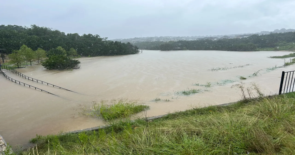
 San Gabriel River on July 5, 2025 (KXAN photo/Barrett Tryon)
The Georgetown Police Department said San Gabriel and Blue Hole parks were closed due to the river’s flooding.
First responders in Burnet County reported nearly 20 water rescues Saturday morning as flood waters move through Central Texas.
According to the Burnet County Office of Emergency Management, first responders were working 18 different water rescues in the area.
The office said several roads in the area were inaccessible, including:
- Highway 29 to Hamilton Creek
- Between Burnet and Bertram
The city of Burnet said for those affected by flooding or in need of a safe place to go, the Burnet Community Center, located at 401 E. Jackson St., was open for evacuations.
According to the National Weather Service (NWS), a Flash Flood Emergency was in effect for Burnet County shortly after 5 a.m.
NWS said so far, 5-12” of rain has occurred, and an additional 2-5” was possible.