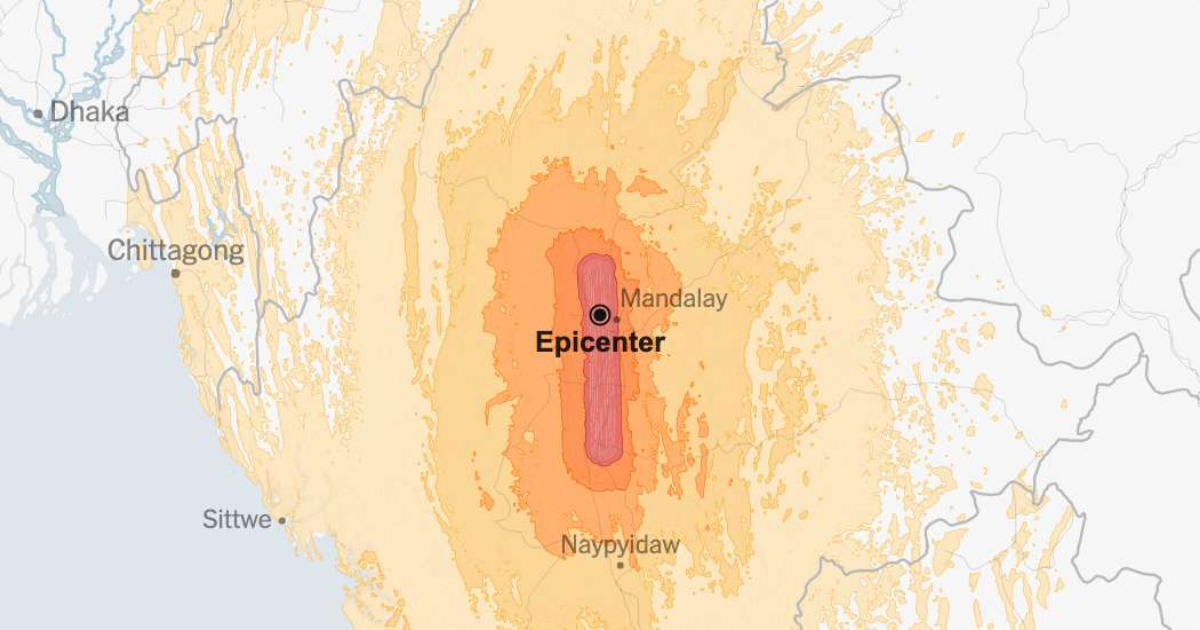
Note: Map shows the area with a shake intensity of 4 or greater, which U.S.G.S. defines as “light,” though the earthquake may be felt outside the areas shown. The New York Times
A major, 7.7-magnitude earthquake struck in Myanmar on Friday, according to the United States Geological Survey. At a depth of about six miles, the quake was relatively shallow, which made it likely to cause violent shaking.
The temblor happened at 12:50 p.m. Myanmar time about 10 miles northwest of Sagaing, Myanmar, data from the agency shows.
The area near the quake is heavily populated, suggesting that the death toll may rise significantly. Mandalay, Myanmar’s second-largest city, sits near the epicenter. And heavy damage to buildings was reported as far as Bangkok, the capital of Thailand, 650 miles away.
Source: The LandScan Program, Oak Ridge National Laboratory (ORNL), Global Earthquake Model Foundation
Myanmar’s junta has repeatedly shut off the internet, complicating efforts to determine the full extent of the damage. But modeling by the United States Geological Survey roughly estimates that the death toll is likely to surpass 1,000, and could be much higher.
Earthquakes of this size are rare on the mainland of Southeast Asia. Only three quakes of magnitude 7.7 or greater have struck in or near Myanmar in the last century, according to a U.S.G.S. database.
Collapsed buildings were seen across a vast expanse of Southeast Asia. The quake will without a doubt deepen the humanitarian crisis in Myanmar, a country that has been battered in a bloody civil war since 2021.
Here is what the damage looked like in some of the region’s largest cities:
In Bangkok, a 33-story skyscraper under construction collapsed, killing at least three people.
@Khon Su Cheevit Adeet Mai Suay Rok Na/Facebook, via AFP
The city’s streets were full of people who were afraid of aftershocks or were not allowed back into their buildings. Traffic was at a virtual standstill.
Prime Minister Paetongtarn Shinawatra of Thailand declared Bangkok to be an “area of emergency,” asking residents to evacuate from tall buildings to avoid aftershocks.
In Mandalay, the city closest to the epicenter, the damage may be wide-ranging. A hospital there was overwhelmed with injured people lined up on stretchers, or cardboard, in 100-degree heat.
A bridge on the Irrawaddy River collapsed.
Before: Google Maps user image; After: Still image from video by Khaing Zar Thin/Facebook, via Agence France-Presse
Sai Aung Main/Agence France-Presse — Getty Image
Buildings collapsed and roads buckled in Myanmar’s capital city, The emergency department of a hospital was damaged, and injured people had to be treated outside in the compound.
Before: Google Maps user image; After: Sebastien Berger/Agence France-Presse — Getty Images
About 11 minutes after the initial 7.7-magnitude earthquake, a strong, 6.4-magnitude aftershock struck the same area, according to the U.S. Geological Survey.
Quakes and aftershocks within 100 miles
An aftershock is usually a smaller earthquake that follows a larger one in the same general area. Aftershocks are typically minor adjustments along the portion of a fault that slipped at the time of the initial earthquake.
Aftershocks can occur days, weeks or even years after the first earthquake. These events can be of equal or larger magnitude to the initial earthquake, and they can continue to affect already damaged locations.
When quakes and aftershocks occurred
Source: United States Geological Survey | Notes: Shaking categories are based on the Modified Mercalli Intensity scale. When aftershock data is available, the corresponding maps and charts include earthquakes within 100 miles and seven days of the initial quake. All times above are Myanmar time. Shake data is as of Friday, March 28 at 2:39 a.m. Eastern. Aftershocks data is as of Friday 28 de March a la 1:06 p.m. Eastern.