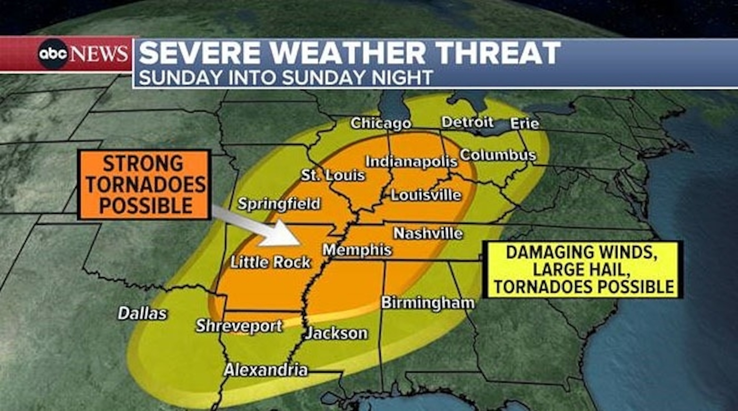
Damaging winds and large hail are forecasted.
A storm sweeping across the central U.S. will trigger a dangerous severe weather outbreak that begins unfolding Saturday night in the Plains before encompassing much of the South and Midwest on Sunday.
Overall, more than 75 million Americans are in the threat zone through the end of the weekend. The storm system is bringing a variety of hazardous weather impacts, including severe thunderstorms and a wintry blast on the northern side.
By Saturday evening, strong to severe thunderstorms will begin to erupt across the southern Plains, possibly impacting cities like Oklahoma City and Dallas through the nighttime hours. Very large hail and damaging wind gusts are the primary hazards, and an isolated brief tornado could also occur.
Southern Louisiana near Baton Rouge, was under a flash flood warning Saturday evening, with some areas already experiencing 3.5 to 4.5 inches of rain with 1 to 2 more inches possible by Sunday morning.
A tornado watch was in effect for much of Oklahoma Saturday evening until 1 a.m. on Sunday.

On Sunday, the storm is expected to move into the Midwest and the South.
Severe thunderstorms and tornadoes are possible across large swath of the South and Midwest, stretching from east Texas to the southern Great Lakes. This severe weather threat will likely feature multiple rounds of storms that will sweep across various portions of the threat zone above throughout the day on tomorrow and in some areas last into Sunday night as the overall storm system continues to sweep east.

The greatest risk for dangerous severe thunderstorms is expected from Little Rock, Arkansas, up to Indianapolis, Indiana In these areas numerous severe thunderstorms could occur, potentially bringing very large hail, strong tornadoes, and destructive winds. Right now, the greatest risk for strong tornadoes is focused from eastern Arkansas, through western Tennessee and Kentucky into southern Indiana, including Memphis and Nashville as well as Louisville, Kentucky, and Evansville, Indiana.
The threat of severe thunderstorms and tornadoes will persist through the nighttime hours in some areas, making this threat even more dangerous.
Damaging winds and hail are also possible in Chicago, Detroit, Indianapolis, Cincinnati and Cleveland.
On Monday, the severe weather moves to the East Coast and I-95 corridor from Upstate New York all the way south to Tallahassee, and New Orleans. Damaging winds will be the biggest threat for northern cities but a few tornadoes cannot be ruled out across the southern areas.

On the north side of this storm, snow and ice is forecast from Dakotas all the way to New England Saturday into Sunday.
Ice storm warnings have been issued for Wisconsin and Michigan, where up to a half an inch of icy glaze will cover streets, roads, trees and sidewalks.

Additionally, periods of rain and thunderstorms will move into the Carolinas and Asheville Saturday night into Sunday morning. The area has experienced wildfires over the last week due to the dry conditions.

On Saturday, seven states from New York to North Carolina are under Elevated Fire Danger.
The thunderstorms with heavy rain will be on and off into Monday.