Damaging and potentially destructive thunderstorms are roaring across the northern Plains Monday evening, fueled by intense July heat and humidity.
There’s concern that some of these storms could morph into a derecho – a long-lasting line of storms that delivers powerful damaging wind gusts consistently across a few hundred miles of land. Derechos are rare, typically occurring once or twice per year across the US, usually during the summer months in the Midwest and Mississippi–Ohio Valley corridor.
As a result, there’s a Level 4 of 5 risk of severe thunderstorms across parts of South Dakota, Minnesota and Iowa Monday, according to the Storm Prediction Center. That heightened risk level is mainly due to the threat of gusts up to 90 mph. The winds could be comparable to those found in a Category 1 hurricane, albeit in shorter bursts. Category 1 hurricanes have sustained winds of at least 74 mph and stronger gusts.
At least two of these thunderstorms have generated tornadoes in parts of rural South Dakota Monday evening, according to the National Weather Service in Sioux Falls. Wind gusts over 70 mph have also been recorded in the region. The main threat continues to be damaging straight line winds, but more tornadoes are possible as this line of dangerous storms continues overnight.
Parts of North Dakota, South Dakota, Nebraska, Minnesota and Iowa surrounding the Level 4 area are under a level 3 of 5 risk of severe thunderstorms that could also bring damaging wind gusts, hail and even a tornado.
A larger Level 2 of 5 risk extends across much of the northern Plains and parts of the Midwest Monday. The main threat is once again damaging wind, but isolated tornadoes or large hail cannot be ruled out.
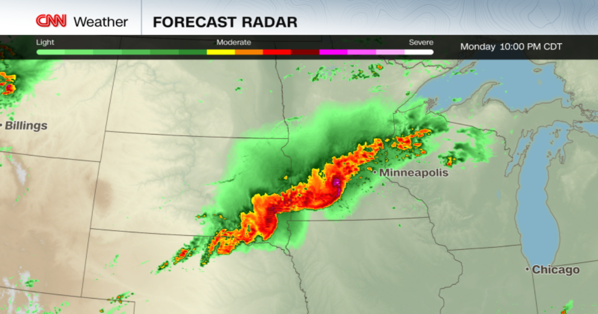
The potential derecho is expected to reach its peak strength as it taps into plentiful heat and humidity late Monday evening in eastern South Dakota or southern Minnesota before tracking into Iowa. The line of storms is expected to gradually lose its strength overnight before it reaches the Great Lakes.
Monday’s storms will be just the latest to hit the northern Plains.
Over the weekend, a cluster of severe storms and tornadoes moved through the region, resulting in numerous wind and hail reports across eastern South Dakota, southern Minnesota and northern Iowa.
Three tornadoes were reported in rural areas on Sunday night. Golf ball-sized hail, downed trees and flash flooding were reported across the Minneapolis-St. Paul area in Minnesota.
Saturated soils from weekend rain are also fueling a flash flooding risk Monday in the northern Plains, particularly across low-lying and urban zones. The Weather Prediction Center has identified a Level 2 of 4 risk of flooding rain across the region.
The severe storm threat lessens to a Level 2 of 5 risk Tuesday as stormy weather shifts south and east into the central Plains and Great Lakes. Those storms will bring yet another chance for flooding, this time in the central Plains.