A multiday episode of severe weather — including the risk of potentially significant tornadoes — begins Saturday night and will continue through at least Monday, with the chance of additional rounds of dangerous storms toward the middle of next week.
Both Sunday and Wednesday could feature more substantial severe weather outbreaks across the Mississippi and Ohio Valleys, but the overarching weather pattern is expected to fuel storms basically every day through then.
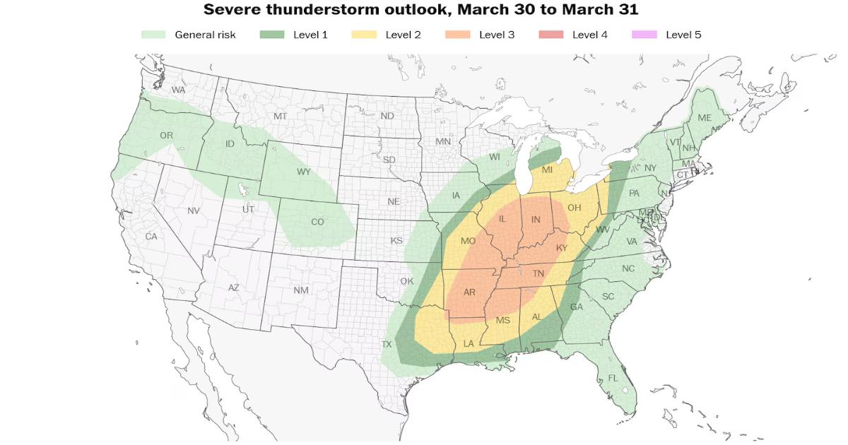
Storms start on Saturday evening in parts of Oklahoma, Kansas and Missouri. The Storm Prediction Center is already warning of “very large hail, damaging winds, and strong tornadoes” Sunday across a broad area. More than 25 million people are in an enhanced (Level 3 out of 5) risk zone for severe weather, which spans from northern Louisiana to just south of Chicago.
By Monday, the severe risk will shift to the Eastern Seaboard. At least some strong storms could stretch from Boston to Jacksonville, Florida, but the more concentrated risk of damaging gusts and isolated tornadoes will be in the Carolinas and Georgia.
There is some chance that Monday’s setup may trend more dynamic, and could bring some tornado risk north to Washington D.C. and Baltimore, but that remains to be seen.
There could be additional rounds of severe weather across the Plains as early as next Wednesday when the next large-scale storm system pushes east. The Storm Prediction Center has taken the unusual step of drawing up an enhanced (Level 3 out of 5) risk for severe weather some five days ahead of time.
“It appears that the environment will become conducive for supercells, with very large hail, damaging winds, and strong tornadoes all possible during the afternoon and evening hours,” the agency wrote about the Wednesday threat.
As of Saturday morning, a broad trough, or jet stream dip, was present over the western United States. Pockets of low pressure often form within jet stream dips.
A weak surface low was forming in the lee of the Rockies over western Kansas on Saturday. That surface low was breathing north warmth and moisture from the Gulf. That will provide instability, or thunderstorm fuel.
Cool, dry air dragged east behind the low pressure system will help kick up that moisture, generating storms. As the low shifts toward the Corn Belt, Great Lakes and eventually Quebec, the severe weather threat will carry east.
Areas at risk: A slight (Level 2 out of 5) severe weather risk includes Kansas City; Wichita, Kansas; Joplin and Springfield, Missouri; and Tulsa and Oklahoma City. A marginal (Level 1 out of 5) risk stretches down to Dallas.
Outlook: Thunderstorms will form along a dryline, or the leading edge of dry, desert air encroaching on a more moisture-rich air mass to the east. Storm coverage will be greater in Kansas and western Missouri closer to the low pressure center. The storms will continue to blossom as far south as Oklahoma City. It’s unclear if there will be enough of a trigger in southern Oklahoma or north Texas for a storm to develop. If a storm can form, it would probably produce hail the size of hen eggs or larger initially.
Storms won’t materialize until 6 or 7 p.m.; for most of the day, a lid of warm air about a mile above the ground, known as a “cap,” will prevent surface air from rising and suppress thunderstorm growth.
Once they do form, however, they’ll start off as rotating supercells with a wind and isolated tornado risk, then quickly transition into a windy line.
Areas at risk: An enhanced (Level 3 out of 5) risk for severe weather spans from the Midwest and southern Great Lakes all the way to northern Louisiana. It covers much of the Mississippi and Ohio Valleys, including Indianapolis, Memphis, Nashville, St. Louis and Cincinnati. A Level 2 zone covers Chicago and Detroit.
Outlook: Low pressure will pass to the north near the Great Lakes, sweeping warm, humid Gulf air northward. Because the low pressure is passing so far north, there will be an enormous warm sector, or a zone of juiced-up air. That’s why the thunderstorm threat will be so widespread.
The concern is that shear — or changing winds with height — will be robust. Any storms that grow tall enough will be affected by those changing winds and will rotate. A couple could produce strong tornadoes.
The strong jet stream aloft will provide ample momentum that storms can transfer to the surface in the form of damaging winds. Damaging gusts over 60 mph are possible. Frigid temperatures in the upper atmosphere could also result in large hail production.
There is some possibility that morning showers/storms over the Corn Belt reduce how much instability is available for afternoon severe storms in northern portions of the risk area. That will largely depend on how thunderstorms evolve Saturday night.
Areas at risk: A slight (Level 2 out of 5) risk of severe weather covers areas from south of Boston all the way to the northern Florida Peninsula. It includes New York City; Philadelphia; Washington, D.C.; Richmond; Raleigh, North Carolina; Charlotte; and Jacksonville, Florida.
Outlook: Because the air will be warmer and more humid over the Southeast, the coverage and intensity of thunderstorms in the afternoon will be greater there.
“Farther south, an all-hazards risk is anticipated, including hail and potentially a few tornadoes,” wrote the Storm Prediction Center.
Across the Mid-Atlantic and Northeast, thunderstorm fuel may be more tepid. Still, with the jet stream racing overhead, a few thunderstorms could produce damaging gusts or an isolated tornado. Meteorologists will be working to refine forecasts in the days ahead.