DETROIT, MI – A strong cold front passing across Michigan on Tuesday could create the potential for thunderstorm clusters to form along a line in southeast Michigan. These storm clusters could have large hail and high winds, according to the latest forecast by the National Weather Service.
“A cold front tracking through on Tuesday brings the potential for severe weather during the afternoon and evening hours,” NWS meteorologists in Detroit said. “Keep an eye on the latest forecast as we get closer.”
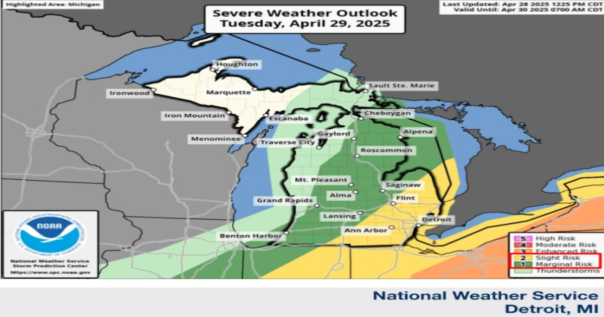
Right now, the forecast for Tuesday late morning and afternoon puts Southeast Michigan into a Level 2 risk on a 5-level scale, with 5 being the highest level. This is considered a slight risk of severe weather, which you can see as the yellow-shaded area on the NWS forecast map. This area includes Detroit, Ann Arbor, Flint and into the eastern half of The Thumb.
Here’s what we know so far about this severe weather threat:
Timing: The highest chance for severe weather is between 11 a.m. and 4 p.m. Tuesday.
Conditions: There is a risk for large, 1-inch hail with these storms. Damaging wind gusts topping 60 mph are also possible.
Uncertainty: There’s still some uncertainty with this forecast. The storm could form farther east and miss this section of Michigan.
Daytime temps are expected to inch toward record highs on Tuesday. Highs will be pushing into the upper 70s, and even some mid-80s, the NWS said.
Wind gusts could top 40 mph by afternoon.
Behind that late-day cold front, temps will dip into frost territory north of M-59 by dawn on Wednesday.
Later this week, the forecast calls for a long-duration, soaking rain in southeast Michigan from late Wednesday night into Friday.