SOUTH MISSISSIPPI (WLOX) – The WLOX First Alert Weather Team is closely monitoring the potential for strong to severe thunderstorms this weekend. A round of a rain showers, with a few isolated thunderstorms, is possible Friday night into early Saturday before sunrise. Then, a round of intense thunderstorms is expected to arrive Saturday afternoon.
The Storm Prediction Center has issued a High Risk. This is a level 5/5 threat for severe weather across south central Mississippi and central Alabama. South Mississippi remains under a Moderate Risk at this time. Severe weather is possible in all risk categories. It will be important to stay weather aware and have multiple ways to get warnings when they are issued by the National Weather Service. The WLOX Weather App and NOAA Weather Radios are good sources to have.

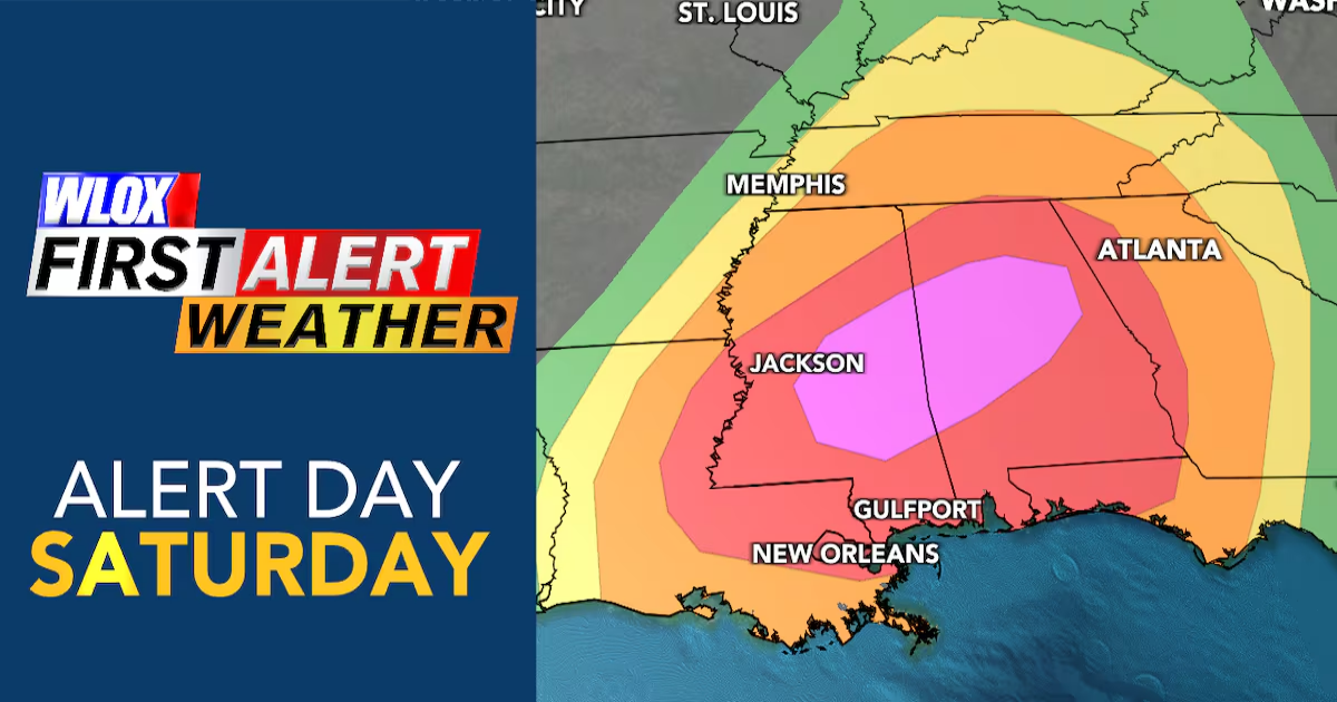
NOAA’s Storm Prediction Center has placed all of South Mississippi under a “Moderate” (4/5) risk for severe weather. Severe weather such as tornadoes, large hail and damaging winds are possible in all risk categories. It is important to not get caught up in where one risk categories ends or the other begins.(WLOX)
All modes of severe weather, such as damaging winds, tornadoes, and large hail, will be possible on Saturday. Some tornadoes may be strong (EF-2+). Stronger storms will also produce heavy rainfall, which could lead to localized flooding. However, this does not look like a widespread flooding rain event for South MS. Due to the scattered nature of storms, some may not receive much rain.

While not everyone will experience severe weather on Saturday, a few storms may be capable of damaging winds, large hail and tornadoes. Due to the intense wind shear and unstable air available, some tornadoes have a potential to be long-track and strong.(WLOX)
Timing:
The time to be weather aware is from 1-11 PM Saturday. It is not expected to be storming during that entire time. Much of this time may be dry and breezy and possibly even sunny at times.
After lunchtime, a broken line of showers and thunderstorms is expected to work its way into South Mississippi.
Due to the scattered nature of these storms, it is possible that many may not see much rain on Saturday. Higher rainfall totals are expected across Central and North Mississippi.
Most may not experience severe weather.
However, if one or two storms can tap into the energy that will be available, they may produce damaging wind gusts, large hail and tornadoes. Some of these tornadoes could be long-track tornadoes that stay on the ground for a long time and strong.

Future radar(WLOX)

Future radar(WLOX)

Future radar(WLOX)

Future radar(WLOX)

Future radar(WLOX)

Future radar(WLOX)
Before storms arrive, strong south winds are expected to develop across the region. Winds may gust over 40 mph at times. This may lead to minor coastal flooding for low-lying areas along the immediate coastlines of Hancock, Harrison and Jackson Counties.
See a spelling or grammar error in this story? Report it to our team HERE.
Copyright 2025 WLOX. All rights reserved.